
FEMA Calculates Risk of Natural Disaster Across Country

A new tool from the federal government attempts to determine the risk associated with natural disasters across the United States.
The National Risk Index was created by the Federal Emergency Management Agency based on calculations by 80 experts over six years with the aim of educating property owners and communities about the importance of being more resilient.
FEMA calculated the relative risk for every county in America for 18 types of natural disasters, such as earthquakes, hurricanes, tornadoes, floods, volcanoes and even tsunamis. That risk is not only the likelihood of an event happening but also the damage it would bring. So heavily populated areas without the capacity for a recovery would be considered at much higher risk than those areas where disaster might strike more frequently but whose residents are more prepared for that outcome.
The risk assessment is divided into county and census tract levels that provide a fairly granular look at the risk of natural disaster for specific property owners.
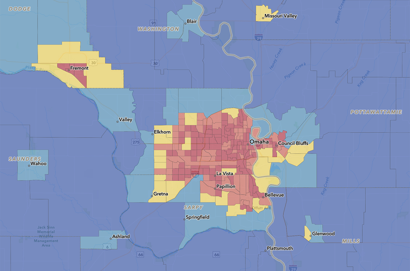
Douglas County falls into the relatively high risk category as a whole, although many of the county’s census tracks are listed as lower risk levels. The county’s expected annual loss from a disaster is very high, its social vulnerability is relatively low, and its community resiliency is relatively high, according to FEMA.
Sarpy County is categorized as relatively low risk overall, with relatively high expected annual loss from a disaster. Its social vulnerability is very low, and its resiliency is very high.
A Daily Record review of the risk assessments by census tracts showed that urban Sarpy County have comparable rates of risk to much of Omaha, although most of the county’s land remains rural. A lower risk is ascribed to communities such as Valley, Bennington, Springfield and Plattsmouth.
While the more populated areas of the metro are deemed relatively high risk, there are pockets where FEMA assesses lower risk, such as Boys Town and Gretna. The assessment also shows Offutt Air Force Base at a relatively moderate risk, although the military base suffered significant damaged from flooding in 2011 and 2019.
Specific hazards that are faced by metro area residents include a very high probability of hail and a relatively high risk related to heat waves, high winds, tornadoes and winter weather.
Douglas County is considered at relatively low risk for cold waves, drought and landslides. Its earthquake and wildfire risk is considered very low. It faces a moderate risk of ice storms, lightning and riverine flooding.
FEMA doesn’t consider Omaha to be at risk of avalanche, coastal flooding, tsunamis, volcanic activity or hurricanes, although derechos weren’t separated from the risk of high wind events.
Out of over 3,000 counties in the United States, Los Angeles County has the highest ranking in the National Risk Index.
FEMA’s top 10 riskiest places in the country also include three counties in the New York City area – Bronx, New York County (Manhattan) and Kings County (Brooklyn) – along with Miami, Philadelphia, Dallas, St. Louis and, in California, Riverside and San Bernardino counties.
By the same measurement, Loudoun County, a Washington, D.C., outer suburb, has the lowest risk of any county, according to FEMA. Three other D.C. suburban counties rank among the lowest risks for counties with larger populations, along with suburban Boston, Long Island, suburban Detroit and Pittsburgh.
The way FEMA calculates the index spotlights places long known as danger spots, like Los Angeles, but some other places highlighted run counter to what most people would think. For instance, eastern cities such as New York and Philadelphia rank far higher on the risk for tornadoes than tornado alley stalwarts Oklahoma and Kansas. And the county with the biggest coastal flood risk is one in Washington state that’s not on the ocean, although its river is tidal.
Those seeming oddities occur because FEMA’s index scores how often disasters strike, how many people and how much property are in harm’s way, how vulnerable the population is socially and how well the area is able to bounce back. And that results in a high risk assessment for big cities with lots of poor people and expensive property that are ill-prepared to be hit by once-in-a-generation disasters.
While the rankings may seem “counterintuitive,” the degree of risk isn’t just how often a type of natural disaster strikes a place, but how bad the toll would be, according to FEMA’s Mike Grimm.
Take tornadoes. Two New York City counties, Philadelphia, St. Louis and Hudson County, New Jersey, are the top five riskiest counties for tornadoes. Oklahoma County, Oklahoma – with more than 120 tornadoes since 1950, including one that killed 36 people in 1999 – ranks 120th. Tornados there are “a low frequency, potentially high-consequence event because there’s a lot of property exposure in that area,” said University of South Carolina Hazards & Vulnerability Research Institute Director Susan Cutter, whose work much of the FEMA calculations are based on. “A small tornado can create a large dollar loss.”
In New York, people are far less aware of the risk and less prepared – and that’s a problem, Grimm said. A few days later, the National Weather Service tweeted that in 2020 several cities, mostly along the East Coast, had more tornadoes than Wichita, Kansas.
In general, Oklahoma is twice as likely to get tornadoes as New York City, but the damage potential is much higher in New York because there are 20 times the people and nearly 20 times the property value at risk.
“It’s that risk perception that it won’t happen to me,” Grimm said. “Just because I haven’t seen it in my lifetime doesn’t mean it won’t happen.”
That sort of denial is especially true with frequent and costly flooding, he said, and is the reason only 4% of the population has federal flood insurance when about one-third may need it.
Disaster experts say people have to think about the big disaster that happens only a few times a lifetime at most, but is devastating when it hits: Hurricane Katrina, Superstorm Sandy, the 2011 super outbreak of tornadoes, the 1906 San Francisco earthquake or even a global pandemic.
“We’re bad at taking seriously risks that happen only infrequently,” said David Ropeik, a retired Harvard risk communications lecturer and author of “How Risky Is It, Really?” “We simply don’t fear them as much as we fear things that are more present in our consciousness, more common. That’s practically disastrous with natural disasters.”
Something like FEMA’s new index “opens our eyes to the gaps between what we feel and what is,” Ropeik said.
Some of FEMA’s risk rankings by disaster type seem obvious. Miami has the highest risk for hurricanes, lightning, and river flooding. Hawaii County is tops in volcano risk and Honolulu County for tsunamis, Dallas for hail, Philadelphia for heat waves and California’s Riverside County for wildfires.
Outside risk expert Himanshu Grover at the University of Washington called FEMA’s effort “a good tool, a good start,” but one with flaws, such as final scores that seem to downplay disaster frequency.
Risks are changing because of climate change and this index doesn’t seem to address that, Ropeik said. FEMA officials said climate change shows up in flooding calculations and will probably be incorporated in future updates.
Explore National Risk Index data and maps at fema.gov/flood-maps/products-tools/national-risk-index.
Seth Borenstein of The Associated Press contributed to this report.
User login


Omaha Daily Record
The Daily Record
222 South 72nd Street, Suite 302
Omaha, Nebraska
68114
United States
Tele (402) 345-1303
Fax (402) 345-2351
222 South 72nd Street, Suite 302 | Omaha, Nebraska 68114 | United States | Tele (402) 345-1303 | Fax (402) 345-2351 | Sitemap